| Ohm | |
|---|---|
 Ohm source east of Ulrichstein | |
| Location | |
| Country | Germany |
| State | Hesse |
| Physical characteristics | |
| Source | |
| • location | Near the town Ulrichstein in the High Vogelsberg region. |
| • elevation | 577 m (1,893 ft) |
| Mouth | |
• location | Lahn, short before the town Cölbe |
• coordinates | 50°51′15″N 8°47′41″E / 50.85417°N 8.79472°E |
• elevation | 188 m (617 ft) |
| Length | 60.7 km (37.7 mi) [1] |
| Basin size | 983.2 km2 (379.6 sq mi) [1] |
| Discharge | |
| • average | 62.6 m3/s (2,210 cu ft/s) |
| Basin features | |
| Progression | Lahn→ Rhine→ North Sea |
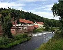
A watermill named Hainmühle (established 1555) near the village Betziesdorf
The Ohm (older Amana[2]) is a river in Hesse, Germany.
It is a right tributary of the Lahn. Its total length is 61 km (38 mi).[1] The Ohm originates in the Vogelsberg Mountains, east of the town Ulrichstein. It flows generally northwest through Ulrichstein, Mücke, Homberg, Amöneburg, Kirchhain, and joins the Lahn in Cölbe, near Marburg. Its largest tributaries are the Seenbach, Felda, Klein, Wohra and Rotes Wasser.
References
- 1 2 3 Water map service of the Hessian Ministry for the Environment, Energy, Agriculture and Consumer Protection (Hessisches Ministerium für Umwelt, Energie, Landwirtschaft und Verbraucherschutz)
- ↑ GREULE, Albrecht 2014. "Deutsches Gewässernamenbuch: Etymologie der Gewässernamen und der zugehörigen Gebiets-, Siedlungs- und Flurnamen". Ed. Walter de Gruyter GmbH
This article is issued from Wikipedia. The text is licensed under Creative Commons - Attribution - Sharealike. Additional terms may apply for the media files.