Commissioners' Plan of 1811
O Commissioners' Plan of 1811 é um plano urbanístico da Cidade de Nova Iorque. No início foi muito criticado pelo excesso de ortogonalidade gerando uma possível sensação de monotonia, em comparação com padrões das malhas urbanas menos regulares de cidades mais antigas.[1]

Imagem de satélite da Cidade de Nova Iorque. Observe ao centro a Ilha de Manhatan que foi submetida ao Commissioners' Plan of 1811.
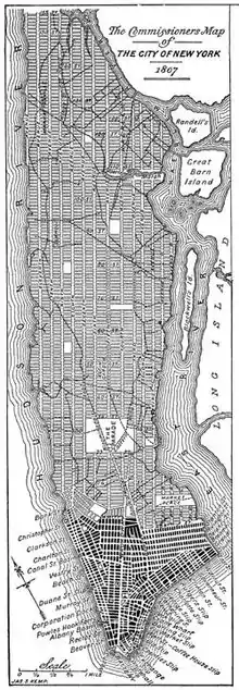
Desenho do plano original.
Ver também
Referências
- Gray, Christopher (23 de outubro de 2005). «Streetscapes: The Commissioners' Plan of 1811: Are Manhattan's Right Angles Wrong?». The New York Times. Consultado em 9 de julho de 2010
Ligações externas
- Commissioners' report of 1807
- "Map of the city of New York and island of Manhattan as laid out by the commissioners appointed by the Legislature, April 3, 1807" New York Public Library Digital Collections (zoomable map)
- The Great American Grid, a website devoted to orthogonal planning.
- The Welikia Project "Beyond Manahatta"
This article is issued from Wikipedia. The text is licensed under Creative Commons - Attribution - Sharealike. Additional terms may apply for the media files.