Cura (distrito)
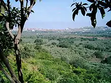
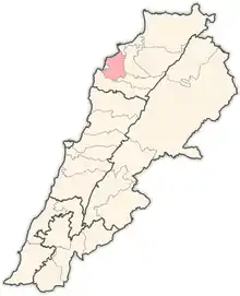
Cura (em árabe: الكورة; romaniz.:Al-Kūrah; em francês: Koura) é um distrito do Líbano Setentrional. Possui 172,6 km² e, segundo o censo de 2017, havia 75 056 habitantes.[1]
Distrito de Koura
| País | |
|---|---|
| Governorate of Lebanon | |
| Sede | |
| Área |
173 km2 |
| Coordenadas |
| Estatuto |
district of Lebanon (en) |
|---|
Cidades
As cidades localizadas em Cura são:[2]
| Cidades | |||
|---|---|---|---|
| 1. Aaba | 2. Afsdik | 3. Ain Akrine | 4. Ali-al-Mouran |
| 5. Amioun | 6. Enfeh | 7. Badebhoun | 8. Barghoun |
| 9. Barsa | 10. Bdebba | 11. Batroumine | 12. Bishmizzine |
| 13. Bhabouch | 14. Bishriyata | 15. Bkomra | 16. Bneyel |
| 18. Btourram | 19. Btouratige | 20. Bkeftine | 21. Bnehran |
| 22. Bsarma | 23. Btaaboura | 24. Bziza | 25. Charlita |
| 26. Chira | 27. Dahr-al-Ain | 28. Darbechtar | 29. Darchmezzine |
| 30. Deddeh | 31. Fih | 32. Ijdebrine | 33. Kaftoun |
| 34. Kifraya | 35. Kelbata | 36. Kelhat | 37. Kfaraakka |
| 38. Kfarhata | 39. Kfarhazir | 40. Kaferkahel | 41. Kfarsaroun |
| 42. Kousba | 43. Maziriit Toula | 44. Mitrit | 45. Mijdel |
| 46. Nakhleh | 47. Rachedbine | 48. Ras Maska | 49. Wata Fares |
| 50. Zakroun | 51. Zakzouk |
Referências
- «Al-Kūrah (District, Lebanon)». City Population
- «Koura District - Localiban». www.localiban.org. Consultado em 15 de janeiro de 2023
This article is issued from Wikipedia. The text is licensed under Creative Commons - Attribution - Sharealike. Additional terms may apply for the media files.