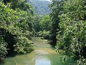
Rio Sarstoon
Rio Sarstoon é um rio centro-americano da Guatemala e Belize com 111 km de comprimento. A sua foz fica no Mar do Caribe. Define a parte mais meridional da fronteira Belize-Guatemala.
| Rio Sarstoon | |
|---|---|
 Rio Sarstoon | |
| Comprimento | 111 km |
| Nascente | Sierra de Santa Cruz |
| Altitude da nascente | 300 m |
| Foz | Mar do Caribe |
| Altitude da foz | 0 m |
| Área da bacia | 2 303 km² |
| País(es) | |
| País da bacia hidrográfica |
|
A parte guatemalteca da sua bacia tem uma superfície de 2109 km²,[1] e a parte belizenha cobre 194 km²,[2]
Ver também
Referências
- INSIVUMEH,Principales ríos de Guatemala.
- NARMAP ,Biodiversity & Environmental Resource Data System of Belize: Sarstoon River. BERDS: Belmopan.
Bibliografia
- «Water Resources Assessment of Guatemala» (PDF). US Army Corps of Engineers. Junho de 2000. Consultado em 23 de novembro de 2010
- «Guatemala - Surface Water Map» (PDF). US Army Corps of Engineers. Junho de 2000. Consultado em 23 de novembro de 2010
- Rand McNally, The New International Atlas, 1993.
This article is issued from Wikipedia. The text is licensed under Creative Commons - Attribution - Sharealike. Additional terms may apply for the media files.