| Site of Special Scientific Interest | |
 | |
| Location | Norfolk |
|---|---|
| Grid reference | TF 990 441[1] |
| Interest | Geological |
| Area | 1.0 hectare (2.5 acres)[1] |
| Notification | 1984[1] |
| Location map | Magic Map |
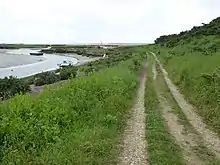
Morston Cliff is a 1-hectare (2.5-acre) geological Site of Special Scientific Interest east of Wells-next-the-Sea in Norfolk.[1][2] It is a Geological Conservation Review site.[3] It is part of Blakeney National Nature Reserve,[4] which is managed by the National Trust,[5] and of the Norfolk Coast Area of Outstanding Natural Beauty.[6]
This key Pleistocene site has the only interglacial deposit of a raised beach in East Anglia. It is believed to be Ipswichian, dating to around 125,000 years ago, and is overlain by glacial deposits of the late Devensian Hunstanton Till.[7]
The Peddars Way and Norfolk Coast Path go through the site.
References
- 1 2 3 4 "Designated Sites View: Morston Cliff". Sites of Special Scientific Interest. Natural England. Retrieved 10 June 2018.
- ↑ "Map of Morston Cliff". Sites of Special Scientific Interest. Natural England. Retrieved 10 June 2018.
- ↑ "Morston Cliff (Quaternary of East Anglia)". Geological Conservation Review. Joint Nature Conservation Committee. Retrieved 25 May 2018.
- ↑ "Designated Sites View: Blakeney". National Nature Reserves. Natural England. Retrieved 1 June 2018.
- ↑ "Blakeney National Nature Reserve". National Trust. Retrieved 1 June 2018.
- ↑ "Norfolk Coast AONB Management Plan 2014-19: Other Conservation Designations within the AONB" (PDF). Norfolk Coast AONB. Retrieved 25 May 2018.
- ↑ "Morston Cliff citation" (PDF). Sites of Special Scientific Interest. Natural England. Retrieved 10 June 2018.

Wikimedia Commons has media related to Morston Cliff.
This article is issued from Wikipedia. The text is licensed under Creative Commons - Attribution - Sharealike. Additional terms may apply for the media files.