Midlands Orientais
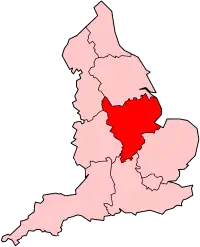
Midlands Orientais ou Midlands do Leste (East Midlands, em inglês) formam uma das nove regiões oficiais da Inglaterra. East Midlands é um termo geográfico criado para descrever a região leste do centro da Inglaterra, conhecida como Midlands. Consiste na área combinada de Derbyshire, Leicestershire, Rutland, Northamptonshire, Nottinghamshire e de a maioria de Lincolnshire.
 Localização | |
| Características geográficas | |
| Área | 15 627 km² |
| População (2011) | 4 533 000 hab. |
| Densidade | 290,07 hab./km² |
| Indicadores | |
| IDH médio | |
| PIB | £ 88 bilhões |
| PIB per capita | £ 17698 |
| Website | www.emcouncils.gov.uk |
Administração local
As regiões oficiais consistem das seguintes subdivisões:
| Mapa | Condado cerimonial | Condado shire /unitário | Distritos |
|---|---|---|---|
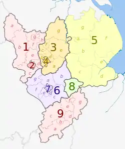 | Derbyshire | 1. Derbyshire | a) High Peak, b) Derbyshire Dales, c) South Derbyshire, d) Erewash, e) Amber Valley, f) North East Derbyshire, g) Chesterfield, h) Bolsover |
| 2. Derby U.A. | |||
| Nottinghamshire | 3. Nottinghamshire | a) Rushcliffe, b) Broxtowe, c) Ashfield, d) Gedling, e) Newark e Sherwood, f) Mansfield, g) Bassetlaw | |
| 4. Nottingham U.A. | |||
| Lincolnshire (parcial) | 5. Lincolnshire | a) Lincoln, b) North Kesteven, c) South Kesteven, d) South Holland, e) Boston, f) East Lindsey, g) West Lindsey | |
| Leicestershire | 6. Leicestershire | a) Charnwood, b) Melton, c) Harborough, d) Oadby e Wigston, e) Blaby, f) Hinckley e Bosworth, g) North West Leicestershire | |
| 7. Leicester U.A. | |||
| 8. Rutland | |||
| 9. Northamptonshire | a) South Northamptonshire, b) Northampton, c) Daventry, d) Wellingborough, e) Kettering, f) Corby, g) East Northamptonshire | ||
This article is issued from Wikipedia. The text is licensed under Creative Commons - Attribution - Sharealike. Additional terms may apply for the media files.