Sesto al Reghena
Sesto al Reghena é uma comuna italiana da região do Friuli-Venezia Giulia, província de Pordenone, com cerca de 5.675 (31 de dezembro de 2004) habitantes. Estende-se por uma área de 40 km², tendo uma densidade populacional de 141,8 hab/km². Faz fronteira com Chions, Cinto Caomaggiore (VE), Cordovado, Gruaro (VE), Morsano al Tagliamento, San Vito al Tagliamento.[1][2][3]
| ||||
|---|---|---|---|---|
| Comuna | ||||
 | ||||
| Localização | ||||
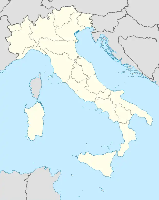 Sesto al Reghena |
||||
| Coordenadas | ||||
| País | Itália | |||
| Província | Pordenone | |||
| Características geográficas | ||||
| Área total | 40 km² | |||
| População total | 5 675 (31/12/04) hab. | |||
| Densidade | 141,8 hab./km² | |||
| Altitude | 13 m | |||
| Outros dados | ||||
| Comunas limítrofes | Chions, Cinto Caomaggiore (VE), Cordovado, Gruaro (VE), Morsano al Tagliamento, San Vito al Tagliamento | |||
| Código ISTAT | 093043 | |||
| Código cadastral | I686 | |||
| Código postal | 33079-33071-33070-33073 | |||
| Prefixo telefônico | 0434 | |||
| Sítio | www | |||
Faz parte da rede das Aldeias mais bonitas de Itália.
Demografia
| Variação demográfica do município entre 1861 e 2011[3] |
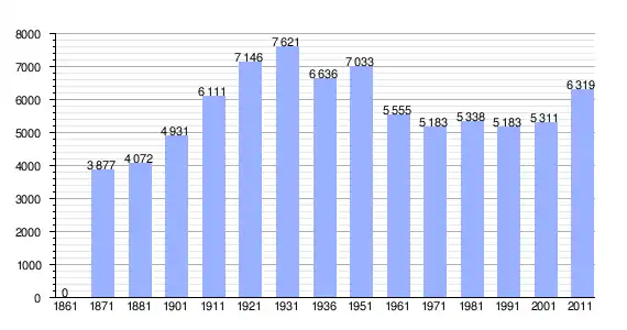 |
| Fonte: Istituto Nazionale di Statistica (ISTAT) - Elaboração gráfica da Wikipedia |
Referências
- «Statistiche demografiche ISTAT» (em italiano). Dato istat
- «Popolazione residente al 31 dicembre 2010» (em italiano). Dato istat
- «Istituto Nazionale di Statistica» 🔗 (em italiano). Statistiche I.Stat
Capital Pordenone | ||
| Comunas | Andreis • Arba • Arzene • Aviano • Azzano Decimo • Barcis • Brugnera • Budoia • Caneva • Casarsa della Delizia • Castelnovo del Friuli • Cavasso Nuovo • Chions • Cimolais • Claut • Clauzetto • Cordenons • Cordovado • Erto e Casso • Fanna • Fiume Veneto • Fontanafredda • Frisanco • Maniago • Meduno • Montereale Valcellina • Morsano al Tagliamento • Pasiano di Pordenone • Pinzano al Tagliamento • Polcenigo • Porcia • Pordenone • Prata di Pordenone • Pravisdomini • Roveredo in Piano • Sacile • San Giorgio della Richinvelda • San Martino al Tagliamento • San Quirino • San Vito al Tagliamento • Sequals • Sesto al Reghena • Spilimbergo • Tramonti di Sopra • Tramonti di Sotto • Travesio • Vajont • Valvasone • Vito d'Asio • Vivaro • Zoppola | |
Lista de comunas na província de Pordenone | ||