A149 (estrada)

A A149 é uma importante estrada no Norfolk, Reino Unido. Ela se estende por cerca de 137 km, de King's Lynn à Great Yarmouth, seguindo parcialmente a rota da Costa North Norfolk.

Pontos de Interesse

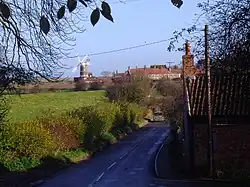
O troço mais pitoresco da A149 compreende o percurso entre King's Lynn e Cromer,de onde se podem contemplar as magníficas paisagens do e litoral Mar do Norte.


Os lugares seguintes som servidos para a estrada:

  • King's Lynn
  • Dersingham
  • Ingoldisthorpe
  • Heacham
  • Hunstanton
  • Holme-next-the-Sea
  • Thornham
  • Brancaster
  • Brancaster Staithe
  • Burnham Deepdale
  • Wayford Bridge
  • Stalham
  • Sutton Staith
  • Catfield
  • Potter Heigham
  • Ormesby St Micheal
  • Caister on Sea
  • Great Yarmouth
AA Box, Brancaster
Clay-next-the-Sea
Estradas do Norfolk (Zone 1)
NúmeroDestino 1Destino 2DistânciaSuperfície
A10LondonKing's Lynn--km (--mi)ASPH
A11LondonNorwich--km (--mi)ASPH/CONC
A12LondonGreat Yarmouth--km (--mi)ASPH
A17Newark on TrentKing's Lynn161 km (100 mi)ASPH
A47BirminghamGreat Yarmouth293 km (182 mi)ASPH
A134ColchesterKing's Lynn--km (--mi)ASPH
A140Needham MarketCromer90 km (56 mi)ASPH
A143HaverhillGreat Yarmouth--km (--mi)ASPH
A146NorwichLowestoft43 km (27 mi)ASPH
A147NorwichCircunda a Norwich--km (--mi)ASPH
A148King's LynnCromer71.0 km (44.1 mi)ASPH
A149King's LynnGreat Yarmouth137.1 km (85.2 mi)ASPH
A1065Barton MillsFakenham64.1 km (39.8 mi)ASPH
A1078King's Lynn PortaA1484.1 km (2.5 mi)ASPH
A1082A149A1482.1 km (1.3 mi)ASPH
This article is issued from Wikipedia. The text is licensed under Creative Commons - Attribution - Sharealike. Additional terms may apply for the media files.