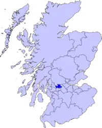
East Dunbartonshire
A Área de Conselho (ou Council Area) de East Dunbartonshire (em gaélico escocês, Siorrachd Dhùn Breatainn an Ear), é uma das 32 novas subdivisões administrativas da Escócia e faz fronteira com: Stirling a norte, North Lanarkshire a leste, Glasgow a sul, West Dunbartonshire a oeste.
| East Dunbartonshire | |
|---|---|
 East Dunbartonshire | |
| Geografia | |
| Área Total | 175 km² (26ª posição) |
| Categoria | Council Area |
| Sede Administrativa | Kirkintilloch |
| Demografia | |
| População Total (2007) | 104.900 habitantes (23ª posição) |
| Densidade | 599 hab./km² |
| Política | |
| Nome do Conselho | East Dunbartonshire Council |
| Site | http://www.eastdunbarton.gov.uk/ |
Esta council area foi formada em 1996, como resulatado de uma lei do governo local escocês de 1994, sobre as áreas dos distritos de Bearsden and Milngavie e Strathkelvin na antiga região de Strathclyde.
Em uma enquete da revista Reader's Digest de 2007 elegeu East Dunbartonshire como o melhor lugar do Reino Unido para se ter uma família[1].
Cidades e aldeias
- Auchenhowie
- Auchinairn
- Auchinreoch
- Baldernock
- Baljaffray
- Balmore
- Bardowie
- Bearsden
- Birdston
- Cadder
- Clachan of Campsie
- Bishopbriggs
- Kirkintilloch
- Lennoxtown
- Lenzie
- Milngavie
- Milton of Campsie
- Torrance
- Twechar
- Waterside
Lugares de interesse
- West Highland Way
- Muralha de Antonino
- Rio Kelvin
- Auld Kirk Museum
Educação
Escolas secundárias
- Bearsden Academy
- Bishopbriggs Academy
- Boclair Academy
- Douglas Academy
- Kirkintilloch High School
- Lenzie Academy
- St Ninian's High School, Kirkintilloch
- Turnbull High School
Referências
This article is issued from Wikipedia. The text is licensed under Creative Commons - Attribution - Sharealike. Additional terms may apply for the media files.