Moray
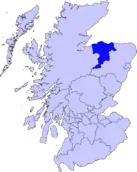
A Área de Conselho (ou Council Area) de Moray (pronuncia-se Muray, e em gaélico escocês, Moireibh), é uma das 32 novas subdivisões administrativas da Escócia, em vigor desde 1996. Localiza-se nas Terras altas da Escócia, faz divisa com Highland ao oeste e Aberdeenshire ao leste e é banhado pela esnseada de Moray Firth, no Mar do Norte.
| Moray | |
|---|---|
 Moray | |
| Geografia | |
| Área Total | 2.238 km² (8ª posição) |
| Categoria | Council Area |
| Sede Administrativa | Elgin |
| Demografia | |
| População Total (2004) | 87.720 habitantes (25ª posição) |
| Densidade | 39 hab./km² |
| Política | |
| Site | http://www.moray.gov.uk/ Moray Council |
Cidades e aldeias
- Aberlour, Alves, Archiestown, Arradoul, Auchenhalrig
- Bogmoor, Broadley, Buckie, Burghead
- Clochan, Craigellachie, Cullen, Cummingston
- Dallas, Deskford, Dipple, Drybridge, Dufftown, Duffus, Dyke
- Elgin
- Findhorn, Findochty, Fochabers, Forres, Fogwatt
- Garmouth
- Hopeman
- Ianstown, Inchberry
- Keith, Kingston, Kinloss
- Lhanbryde, Longmorn, Lossiemouth
- Mill of Tynet, Mosstodloch,
- Nether Dallachy, Newmill
- Ordiquish
- Portgordon, Portknockie
- Rathven, Rafford, Rothes, Rothiemay
- Spey Bay
- Tomintoul
- Unthank, Upper Dallachy, Urquhart
Ligações externas
- «Moray Council» (em inglês)
- «Moray Local Community webpages» (em inglês)
This article is issued from Wikipedia. The text is licensed under Creative Commons - Attribution - Sharealike. Additional terms may apply for the media files.